Thinking about selling your hunting land in Oconee County? Buyers love a good tract, but they will walk away fast if access is unclear, roads are rough, or documents are missing. The good news: with a few focused steps, you can make your land easy to show, simple to evaluate, and ready to close. This guide walks you through what to fix, what to gather, and which local resources to use so you reduce friction and speed up the sale. Let’s dive in.
What buyers expect in Oconee County
Serious buyers look for a few core items right away. First is clear, legal access with any road maintenance plan spelled out. If your driveway ties into a county route, check encroachment or driveway rules with Oconee County Planning & Zoning and Roads & Bridges.
They also expect passable internal roads or trails, visible parking or campsite areas, and safe gate access. Finally, a tidy data packet builds trust: deed and plat, soils and flood info, basic timber and habitat notes, and any active leases. The Oconee County Parcel Viewer helps you confirm parcel details and create quick reference maps.
Step 1: Verify legal access
If access is unclear or only prescriptive, many buyers will not proceed. Confirm how the property connects to a public road or a recorded easement.
- Use the Oconee County Parcel Viewer and your recorded deed to verify road frontage or easements. Save copies of any maintenance agreements.
- If your driveway meets a county right-of-way, contact Roads & Bridges or Planning & Zoning about encroachment or driveway permits. Start early if you plan improvements.
- Write down who maintains any shared private road and include neighbor contact info in your data packet.
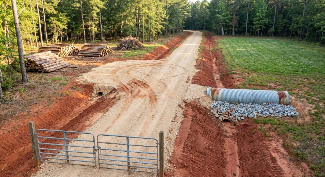
Step 2: Improve access, gates, and signage
Buyers and loggers price in road work. Fixing small issues now can protect offers later.
- Prioritize the main access route. Regrade ruts, improve drainage, and ensure culverts are sized and passable. Before altering anything in a right-of-way, confirm requirements with Roads & Bridges.
- At gates, post contact info and use one consistent access method for showings. A labeled combo or lockbox keeps visits smooth and secure.
- Add a short written directions note from a known highway and include a GPS centroid for the listing and showings.
Step 3: Confirm boundaries and mark corners
Clear boundaries reduce risk and speed up due diligence. Buyers want to see where the lines are.
- Pull your deed, plat, and tax records from the Oconee County Assessor. Include prior surveys if you have them.
- If boundaries are unclear, consider ordering a current boundary survey. For showings, flag lines and corners or have a surveyor install visible markers where practical.
Step 4: Document timber and habitat
Timber and wildlife habitat often drive value on hunting tracts. Provide simple, honest facts that buyers can verify.
- Summarize stand types and age classes, note mast species, travel corridors, ponds or seeps, and any recent management like thinning, prescribed fire, or food plots. If you have a stewardship or wildlife plan, include it. The SC Forestry Commission offers landowner guidance and can point you to consulting foresters.
- If timber value matters on your tract, consider a timber cruise or evaluation. Use statewide timber price trends only as context since stumpage is site specific.
- Add clear photos of stands, roads, gates, food plots, and water features. A simple stand map helps buyers visualize access and harvest potential.
- For habitat projects or contractor ideas, review SCDNR’s wildlife technical assistance resources.
Step 5: Check soils and septic feasibility
Many buyers want a primitive camp or future cabin. Show them where it can work.
- Run a soils snapshot using the NRCS Web Soil Survey. Print the soils map and note any septic or foundation constraints.
- If buildability is part of your story, consider a site-specific perc or septic feasibility check. Buyers appreciate clarity on next steps with county and state approvals.
Step 6: Know your wetlands and flood zones
Floodplains and wetlands shape both value and permitting. Map them early so buyers can plan uses and budgets.
- Confirm flood zones using FEMA’s NFHL. Include a screenshot or panel reference from the FEMA Map Service in your packet.
- Review possible wetlands with the USFWS mapper. The National Wetlands Inventory is a mapping tool for screening only. It is not a regulatory determination.
- If you plan any activity that affects streams or wetlands, contact the U.S. Army Corps of Engineers early for guidance on permits or jurisdictional determinations. Start with the Corps’ Regulatory Program and Permits overview.
Step 7: Permits, timelines, and taxes
Oconee County uses an online portal for many permits and approvals. It pays to start early.
- For encroachment, plat approvals, or development questions, go to Oconee County Planning & Zoning to access the CitizenServe portal and contact info.
- If your tract is in South Carolina’s agricultural or timber use-valuation program, confirm current classification and filing deadlines with the Oconee County Assessor. A change in use can trigger rollback taxes, so disclose your current status and ask buyers to plan accordingly.
Build a seller data packet buyers trust
Package your information in a labeled folder with a one-page summary up front. Include:
- Deed and owner vesting information
- Parcel ID and recent tax bill
- Current plat or survey, or note if a survey is ordered
- Recorded easements, rights-of-way, covenants, and any road maintenance agreements
- Topo and soils maps, plus FEMA flood panel and any wetlands screenshots
- Timber documents, recent harvest notes, and any stewardship or wildlife plans
- A wildlife and habitat summary: food plots, mast trees, bedding cover, funnels, water sources, blinds or stands if included
- Copies of active leases and their termination or transfer terms
- List of recent improvements with dates and photos
- Utilities contact info and whether water, sewer, or electric are at the road
Quick prep checklist
Verify legal access and gather easements or maintenance agreements. If needed, contact Planning & Zoning or Roads & Bridges about driveway rules.
Pull assessor and deed records, plus your plat or survey. If boundaries are unclear, consider a current survey.
Run soils and flood checks using NRCS and FEMA. Flag any constraints for disclosure.
If timber or habitat is a key selling point, get a timber cruise or at least a stand summary. Add photos and a simple stand map.
Grade the main access route, confirm culverts and bridges are passable, and set up clean gate access for showings. Check county requirements before touching the right-of-way.
Assemble your seller data packet and share it with qualified buyers or your land agent.
Why this work pays off
When you remove question marks up front, buyers spend less time in due diligence and feel more confident making a strong offer. Clean access and roads reduce surprise costs. Straightforward maps and documents show that you care about a smooth transfer.
If you are unsure where to start, focus on access, boundaries, soils and flood, then timber and habitat. These items answer most first-call buyer questions and shorten timelines.
Ready to list your Oconee hunting land?
You only get one chance to make a first impression. If you want a seasoned land broker who understands timber, habitat, and the county process, reach out to Joseph Cann for a local, market-ready plan.
FAQs
What counts as legal access in Oconee County?
- Buyers look for public road frontage or a recorded easement and any road maintenance agreement. Verify these through the deed and the county parcel viewer.
Do I need permits to improve a driveway or culvert?
- If your access ties into a county right-of-way, check with Planning & Zoning or Roads & Bridges for possible encroachment or driveway permits before you start work.
How do buyers evaluate timber value on a hunting tract?
- Many request a timber cruise or consulting forester’s opinion and review stand age, species mix, recent harvests, and access for logging trucks.
How can I screen my land for cabin or campsite feasibility?
- Start with the NRCS Web Soil Survey for septic and soil constraints, then pursue site-specific testing if a build site is part of your plan.
What is the difference between wetlands maps and permits?
- USFWS NWI and FEMA maps are screening tools, not approvals. For any work near streams or wetlands, contact the U.S. Army Corps of Engineers about permits early.
Will changing use affect my property taxes?
- South Carolina’s use-valuation rules for ag and timber land can change with a new use, and rollback taxes may apply, so confirm current status and deadlines with the county assessor.